INNOVATIVE, PRECISE & EFFICIENT

Reality Capture & Data Processing for Infrastructure

See your infrastructure assets from a higher perspective

Geospatial Solutions

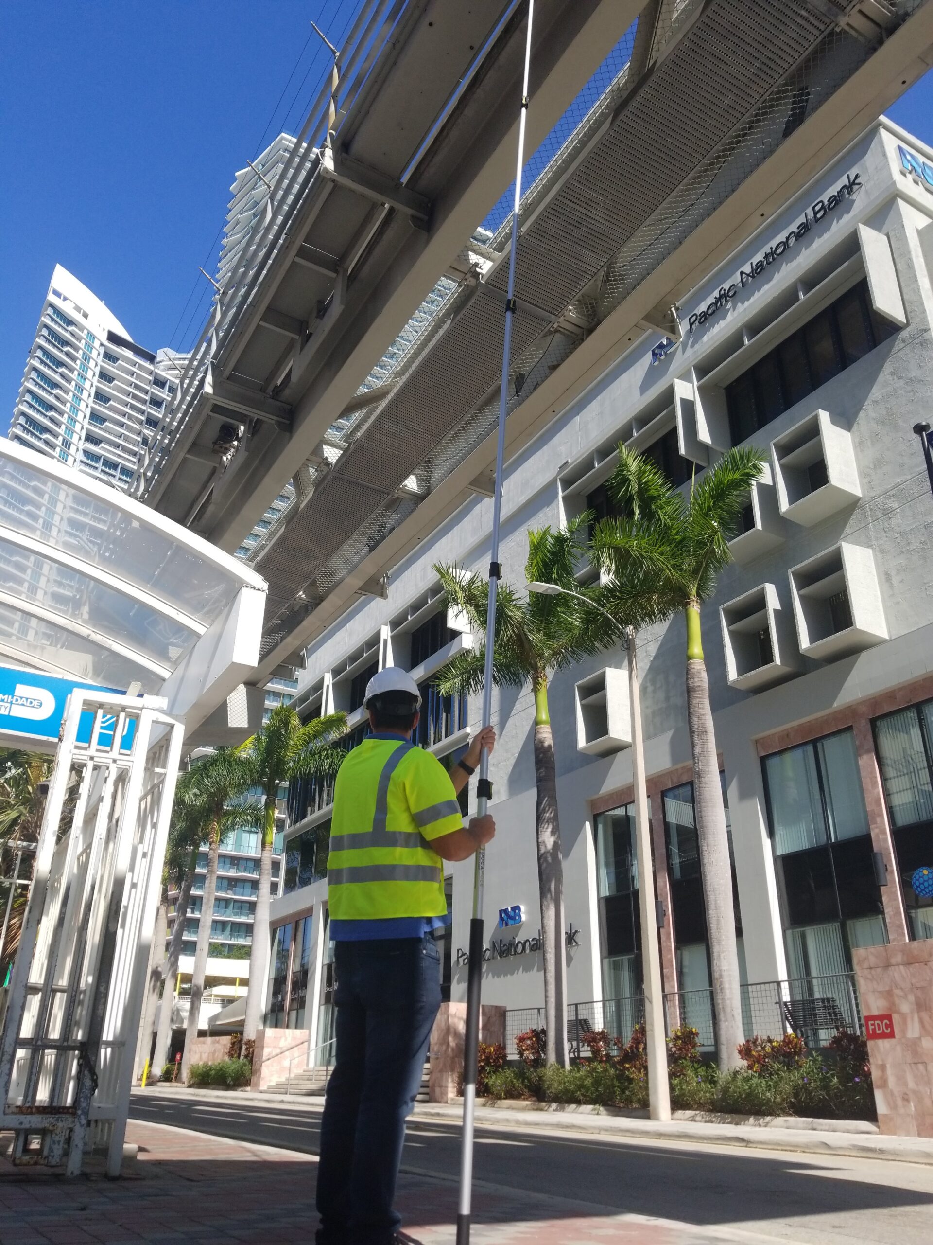
We provide comprehensive geospatial services, delivering precise insights for various industries. Our end-to-end solutions ensure success in every project.

Advanced Analytics

We leverage state-of-the-art drone technology, LiDAR, and GIS to deliver precise and actionable data. Our innovative approach ensures success across all projects.

Client Focus

We aim to provide tailored, client-focused solutions and to exceed expectations. Our collaborative approach drives success, with the goal of positively impacting the communities we serve.

About Us

Leading the Way in Geospatial Innovation

“At Digital E Consulting, we empower our clients with advanced geospatial and aerial insights, reducing risks, cutting costs, and enhancing efficiency through cutting-edge technology and precise data analytics.”

Digital E Consulting LLC is a trusted provider of geospatial and aerial Non-Destructive Testing (NDT) services, specializing in Architecture, Engineering, Construction, and Land Survey applications. Founded in 2018, our company leverages cutting-edge technology to deliver actionable insights and data-driven solutions.

Our team of experienced drone pilots and technicians utilize the latest technologies in Unmanned Aircraft Systems (UAS) to collect high-resolution aerial data. This approach enhances safety on the worksite, reduces costs, and ensures quick turnaround times, enabling our clients to access and analyze critical data efficiently.

Years of Experience
0 +

Our Clients

Trusted by Industry Leaders Worldwide

Understanding our clients’ unique needs is at the heart of everything we do, and we are committed to exceeding expectations in every project. We are deeply grateful for the trust our clients place in us, and we believe that by delivering our best, we help create a better community and world. Through our dedicated service, we aim to build lasting partnerships and make a positive impact.

Industries Served

OUR MARKETS

At Digital E Consulting, we provide tailored geospatial solutions across diverse industries, including Construction, Land Surveying, Civil Engineering, and Research. Our advanced data analytics and reality capture services are designed to meet the unique challenges of each field, delivering precise insights that enhance project outcomes. Discover how our expertise can empower your industry and help you achieve your goals.

Land Survey

Unlocking Precision with Advanced Geospatial Solutions

Construction

Elevating Construction Projects with Advanced Geospatial Solutions

Civil Engineering & Transportation

Innovative Geospatial Solutions for Infrastructure Development

Nonprofits and Research

Empowering Nonprofits and Researchers with Geospatial Intelligence

Environment, Agriculture & Natural Resources

Mapping the Future of Agriculture and Environmental Stewardship

Sustainability & Resilience

Driving Resilience Through Precision Data

DEC Portfolio

Successful projects that our company has completed

Turning Bold Visions into Measurable Successes, Project by Project

// Assets Management

Transforming Data into Actionable Insights with GIS

// Building & Infrastructure

View your Property In 3D

// Immersive 3D Environments

Digital Twins That Reflect Realities

// Construction

View your site from above

// Stockpile

Surfaces for volumetric calculations

// photogrammetry

2D and 3D modeling using advanced photogrammetry tools
Industries Served
0 +
UAV Flight Time
0 +
TB of Data Processed
0 +
Unique Sites Captured
0 +

Our Team

Valuing Our People, Strengthening Our Community

Our Mision

At Digital E Consulting, we believe in making a positive impact on both our profession and our community. We are committed to providing top-notch services while actively participating in community and professional events throughout the region. Our involvement includes supporting local philanthropic initiatives, contributing to professional societies, and fostering a sense of family within our company culture.

Our vision

Our vision is to lead the geospatial industry through innovation and excellence. We aim to empower sustainable growth and elevate professional standards, while making a meaningful impact in the communities we serve. Committed to integrity and continuous learning, we strive to shape a better future for our clients, our team, and society. Together, we are building a brighter tomorrow.

Driving Innovation, Empowering Communities

At the heart of our mission is a commitment to pushing the boundaries of innovation while uplifting the communities we serve. We believe that true progress comes from combining cutting-edge solutions with a deep sense of responsibility toward the people and places that shape our world.

"Our employees are encouraged to reach their full potential both professionally and personally. We take pride in our ability to give back and make a meaningful difference in the local community. Our work not only enhances the projects we undertake but also contributes to the well-being and advancement of the communities we serve."
Alexander Nunez
President/Founder

CORE SERVICES

A Range of Services Designed for Every Client

We understand that every project has its own unique challenges and requirements. That’s why we offer a variety of plans, each specifically tailored to meet your individual needs, ensuring that you have the right support and resources at every step of your journey.

Aerial Data Capture

Data Processing

Data Visualization

Let’s Discuss Your Needs—Get Started Now

Get in touch

Partner with Us

We’re Here to Help You Succeed

Call Us

Your Questions, Answered

786-465-7434

Office Address

We’d Love to Meet You—Book an In-Person Appointment

1951 NW 7th Ave #600, Miami, FL 33136

Digital E Consulting

Empowering Projects with Cutting-Edge Drone and Data Insights
- Start Your Journey with Us -